
Re-Mapping Our Roads for Self-Driving Cars
Self-driving cars appear to be in our future. Successful test runs of this technology from Uber and Waymo show that it is feasible to let our vehicles drive us automatically to where we need to go.
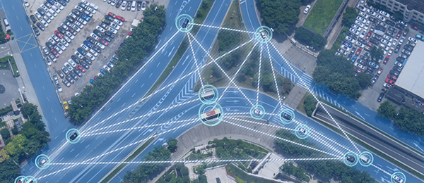
That means these new vehicles must process a lot of information while driving. Autonomous cars will require information about the speed limit, street quality, and traffic signal placement to ensure a safe experience. That means we need to start thinking about mapping our roads in a different way to accommodate this technology.
Why Do High-Definition Maps Matter?
Uber and Waymo are pursuing internal mapping programs to support their autonomous technologies.
Waymo is sending three Chrysler Pacifica minivans to Los Angeles to collect data on the street grid for several months. The information will include road surface types, the location of stoplights, and the exact height of curbs.
It isn’t the “normal” kind of map that drivers think about when traveling. Autonomous cars care more about what the speed limit is or the condition of the road instead of its name.
Uber sent two Volvo XC90 SUVs to Dallas to complete similar tasks. The only difference from Waymo is that the company is considering autonomous vehicles in the city when matching with future customers. There will also be map-building efforts going to Toronto, San Francisco, and Pittsburgh.
These New Maps Must Meet Critical Demands
Autonomous vehicles require pre-mapped scenes as a way to compensate for their inability to operate from context only. Sensor data cannot offer a viable substitute when a traffic signal is coming, and there is a blockage preventing it from being observed.
That’s why Uber and Waymo are focused on re-mapping with three several crucial areas in mind.
- Improved Precision
The new maps allow for the driverless vehicle to understand the context of its position with enhanced reliability. This technology lets it “see” itself within a 10-centimeter radius.
- Real-Time Instructions
Re-mapping gives autonomous vehicles information about the current lane of travel. It will provide data about the current speed limit, highway elevation, or overhead clearance requirements.
- Constant Connectivity
There are times when vehicles must travel through long tunnels or in remote areas where GPS is missing or weak. The presence of an on-board map can allow the technology to continue functioning despite the lack of a signal.
What has kept companies from performing this work in the past has been the cost of collecting and updating the data. It is a time-consuming process because cities are continuously evolving in shape and size. There is also the amount of information to consider.
When Google developed Street View, it took 20 petabytes of data to chart 5 million miles of roads in 2012. That could be equal to the information collected from one city for this type of map.
As hardware footprints become lightweight and scalable, it will become possible to deliver accuracy and affordability in the same package. Uber and Waymo are taking the lead on this effort, which means their driverless vehicles are going to arrive sooner rather than later.